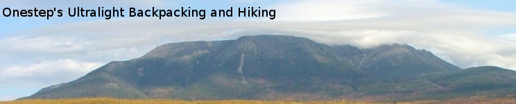
My Appalachian Trail Section Hikes
 My first
Appalachian Trail hike was in
1972.
What started out as a week long adventure had turned into a life long
passion. It took me 31 years to complete the A.T. one section at a
time. In 2003 I earned my "2000 Miler" status atop Pleasant Pond Mtn in
Maine. To quote Ed Garvey, it truly was "An Adventure of a Lifetime".
My first
Appalachian Trail hike was in
1972.
What started out as a week long adventure had turned into a life long
passion. It took me 31 years to complete the A.T. one section at a
time. In 2003 I earned my "2000 Miler" status atop Pleasant Pond Mtn in
Maine. To quote Ed Garvey, it truly was "An Adventure of a Lifetime".
Backpacking
My first backpacking trip in 1972 was with a group of guys called the Mosquito Hill Gang. We followed the Appalachian Trail for a week with an assortment of gear that ranged from heavy to heavier. That was not an ultralight backpacking trip!
In 1976 I attempted a thru hike of the 2000 mile Appalachian Trail. That hike ended in Waynesboro VA after 700 miles and two months of backpacking.
Years went by and I still wanted to "hike the whole trail". In 1996 I decided to complete the trail one section at a time. What I had each year was a limited amount of time to spend section hiking. I soon began to believe that I would never complete the whole Appalachian Trail.
Beyond Backpacking
 In 1999 I
"discovered" the book Beyond Backpacking : Ray Jardine's
Guide To Lightweight Hiking. In it I discovered his amazing
philosophy of ultralight backpacking. Around the same time I finally
got "on-line" and discovered both Michael's, and JohnO's, Ultralight
Backpacking pages. A light went on! Maybe if I carry less weight, I
could hike more miles per day, and that would allow me to complete the
Appalachian Trail IN THIS LIFETIME !!!
In 1999 I
"discovered" the book Beyond Backpacking : Ray Jardine's
Guide To Lightweight Hiking. In it I discovered his amazing
philosophy of ultralight backpacking. Around the same time I finally
got "on-line" and discovered both Michael's, and JohnO's, Ultralight
Backpacking pages. A light went on! Maybe if I carry less weight, I
could hike more miles per day, and that would allow me to complete the
Appalachian Trail IN THIS LIFETIME !!!
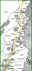
Section Hikes
What follows is a list of each of my A.T. section-hikes. The list is in chronological order starting with my first hike in 1972.
| 1972 | 37.5 miles | Maine - Rt 17 to Rt 27 | ||
| 1973 | 40.1 miles | Maine - Rt 201 to Rt 27 | ||
| 1975 | 33.3 miles | Maine - Rt 26 to Rt 17 | ||
| 1976 | 883.9 miles | GA->VA - Springer Mtn GA to Waynesboro VA | ||
| 1976 | 23.9 miles | NH->ME - Rt 2 to Rt 26 | ||
| 1980 | 54.3 miles | Maine - JoMary Rd to Katahdin | ||
| 1995 | 24.0 miles | Maine - Moxie Pond to Rt 15 | ||
| 1996 | 43.3 miles | Maine - JoMary Rd to Long Pond Stream | ||
| 1996 | 14.4 miles | Maine - Long Pond Stream to Rt 15 | ||
| 1996 | 7.0 miles | Maine - Rt 201 to Pleasnat Pond Mtn | ||
| 1997 | 15.2 miles | New Hampshire - Rt 2 to Carter Notch | ||
| 1997 | 5.9 miles | New Hampshire - Carter Notch to Pinkham Notch | ||
| 1997 | 26.0 miles | New Hampshire - Pinkham Notch to Crawford Notch | ||
| 1997 | 79.3 miles | New Hampshire - Dartmouth Skiway to Crawford Notch | ||
| 1998 | 11.4 miles | New Hampshire - Dartmouth Skiway to Etna Rd | ||
| 1998 | 22.2 miles | NH->VT - Hanover NH to Rt 12 VT | ||
| 1999 | 128.4 milse | VT->MA - Rt 12 VT to N Adams MA | ||
| 2000 | 14.0 miles | Massachusetts - N Adams to Cheshire | ||
| 2000 | 194.6 miles | MA/CT/NY - Cheshire MA to Arden NY | ||
| 2001 | 266.1 miles | NY/NJ/PA - Arden NY to Boiling Springs PA | ||
| 2002 | 147.4 miles | VA/WV - Waynesboro VA to Harpers Ferry WV | ||
| 2003 | 98.7 miles | WV->PA - Harpers Ferry WV to Boiling Springs PA | ||
| 2003 | 6.0 miles | New Hampshire - Hanover to Etna Rd | ||
| 2003 | 4.9 miles | Moxie Pond to Pleasant Pond Mtn! |